filter-iconFilter
close-icon
Media type
License type
Orientation
Exclude

Oceania Map Stock Photos And Images

Oceania sign with the map of continent and colored stripes vector illustration can be used as insignia label sticker or badge of the oceania
Oceania sign with the map of continent and colored stripes vector illustration can be used as insignia label sticker or badge of the oceania123RF Premium
VectorsSimilar Images
Australia and oceania region map of countries in south pacific ocean vector illustration Vector Illustration
Australia and oceania region map of countries in south pacific ocean vector illustration123RF Premium
VectorsSimilar Images
Location of nauru on the world map with enlarged map of nauru with flag geographical vector template for your design
Location of nauru on the world map with enlarged map of nauru with flag geographical vector template for your design123RF Premium
VectorsSimilar Images
Vector of political map of oceania set with buttons flags on white background
Vector of political map of oceania set with buttons flags on white background123RF Premium
VectorsSimilar Images
Location of kiribati on the world map with enlarged map of kiribati with flag geographical vector template for your design Stock Photo
Location of kiribati on the world map with enlarged map of kiribati with flag geographical vector template for your design123RF Premium
VectorsSimilar Images
Illustration of papua new guinea as seen from earth’s orbit on planet earth 3d illustration
Similar Images
Map of australia oceania with borders as scrible
VectorsSimilar Images
Map of oceania white geographic map physics cartography geographical atlas
Map of oceania white geographic map physics cartography geographical atlas123RF Premium
Similar Images
Smooth map of australia continent
Smooth map of australia continent123RF Premium
VectorsSimilar Images
East asia and oceania map detailed vector illustration Stock Photo
East asia and oceania map detailed vector illustration
VectorsSimilar Images
Papua new guinea during sunset highlighted in red on planet earth with clouds 3d illustration
Similar Images
Set of vector polygonal maps of oceania bright gradient map of continent in low poly style multicolored oceania map in geometric style for your infographics attractive vector illustration
Set of vector polygonal maps of oceania bright gradient map of continent in low poly style multicolored oceania map in geometric style for your infographics attractive vector illustration123RF Premium
VectorsSimilar Images
Oceania map actual low poly style continent map splendid vector illustration
VectorsSimilar Images
Papua new guinea on political globe with embedded flags 3d illustration isolated on white background
Similar Images
New zealand in red on model of planet earth hovering in space 3d illustration isolated on white background Stock Photo
New zealand in red on model of planet earth hovering in space 3d illustration isolated on white background
Similar Images
Oceania colorful low poly continent shape multicolor geometric triangles modern trendy design vector illustration
Oceania colorful low poly continent shape multicolor geometric triangles modern trendy design vector illustration123RF Premium
VectorsSimilar Images
Australia and oceania map vintage detailed vector illustration Stock Photo
Australia and oceania map vintage detailed vector illustration
VectorsSimilar Images
Australia on 3d earth with visible countries and blue oceans with waves 3d illustration
Similar Images
Location of marshall islands on the world map with enlarged map of marshall islands with flag geographical vector template for your design Stock Photo
Location of marshall islands on the world map with enlarged map of marshall islands with flag geographical vector template for your design123RF Premium
VectorsSimilar Images
Oceania single states political map geographic region southeast of the asia pacific region including australasia melanesia micronesia and polynesia english illustration over white vector
Oceania single states political map geographic region southeast of the asia pacific region including australasia melanesia micronesia and polynesia english illustration over white vector123RF Premium
VectorsSimilar Images
Planet earth with highlighted papua new guinea in space with moon and milky way visible city lights and country borders 3d illustration
Similar Images
Papua new guinea from orbit of planet earth at night with highly detailed surface textures with visible border lines and city lights 3d illustration Stock Photo
Papua new guinea from orbit of planet earth at night with highly detailed surface textures with visible border lines and city lights 3d illustration
Similar Images
East asia and oceania map vintage detailed vector illustration
VectorsSimilar Images
Political map of australia with the several states Stock Photo
Political map of australia with the several states
VectorsSimilar Images
Australia and southeast asia map white lands and grey water high detailed political map of australian and southeastern asia region with country capital ocean and sea names labeling Vector Illustration
Australia and southeast asia map white lands and grey water high detailed political map of australian and southeastern asia region with country capital ocean and sea names labeling123RF Premium
VectorsSimilar Images
Oceania map actual low poly style continent map wonderful vector illustration Stock Photo
Oceania map actual low poly style continent map wonderful vector illustration
VectorsSimilar Images
Papua new guinea from space on planet earth with digital network representing international communication technology and travel 3d illustration Stock Photo
Papua new guinea from space on planet earth with digital network representing international communication technology and travel 3d illustration
Similar Images
Australia and southeast asia detailed political map with lables
Australia and southeast asia detailed political map with lables123RF Premium
VectorsSimilar Images
World map three dimensional 3d background Stock Photo
World map three dimensional 3d background123RF Premium
VectorsSimilar Images
World map continental background
VectorsSimilar Images
Australia from space on realistic model of planet earth with country borders and detailed planet surface and clouds 3d illustration Stock Photo
Australia from space on realistic model of planet earth with country borders and detailed planet surface and clouds 3d illustration
Similar Images
Papua new guinea on bright political globe with embedded flag 3d illustration
Similar Images
Highly detailed planet earth in the morning exaggerated precise relief lit morning sun detailed earth australia and papua new guinea 3d rendering
Similar Images
Papua new guinea blue map with neighboring countries and names vector illustration
Papua new guinea blue map with neighboring countries and names vector illustration123RF Premium
VectorsSimilar Images
Australia map located on a world map with flag and map pointer or pin infographic map vector illustration isolated on white Stock Photo
Australia map located on a world map with flag and map pointer or pin infographic map vector illustration isolated on white
VectorsSimilar Images
A vintage sepia coloured map of oceania Stock Photo
A vintage sepia coloured map of oceania123RF Premium
Similar Images
Australia and oceania physical map elements build your own geography info graphic collection vector illustration Stock Photo
Australia and oceania physical map elements build your own geography info graphic collection vector illustration
VectorsSimilar Images
New zealand from space on planet earth with digital network representing international communication technology and travel 3d illustration Stock Photo
New zealand from space on planet earth with digital network representing international communication technology and travel 3d illustration
Similar Images
Australia and oceania map brown orange hue colored on dark background high detailed political map of australian and pacific region with country ocean and sea names labeling
Australia and oceania map brown orange hue colored on dark background high detailed political map of australian and pacific region with country ocean and sea names labeling123RF Premium
VectorsSimilar Images
Oceania map Stock Photo
Oceania map
VectorsSimilar Images
Papua new guinea in red on model of planet earth on reflective blue surface 3d illustration Stock Photo
Papua new guinea in red on model of planet earth on reflective blue surface 3d illustration
Similar Images
Australia and oceania map detailed vector illustration
VectorsSimilar Images
Australia from space planet earth with country borders and extremely high detail of planet surface and clouds 3d illustration
Similar Images
Australia on planet earth with country borders and highly detailed planet surface and clouds 3d illustration
Similar Images
New zealand round sign futuristic satelite view of the world centered to new zealand country badge with map round text and binary background captivating vector illustration
New zealand round sign futuristic satelite view of the world centered to new zealand country badge with map round text and binary background captivating vector illustration123RF Premium
VectorsSimilar Images
Location of samoa on the world map with enlarged map of samoa with flag geographical vector template for your design
Location of samoa on the world map with enlarged map of samoa with flag geographical vector template for your design123RF Premium
VectorsSimilar Images
Sunset above papua new guinea highlighted in red on planet earth with visible country borders 3d illustration Stock Photo
Sunset above papua new guinea highlighted in red on planet earth with visible country borders 3d illustration
Similar Images
East asia and oceania map detailed vector illustration Stock Photo
East asia and oceania map detailed vector illustration
VectorsSimilar Images
Australia and oceaniaa map detailed vector illustration
VectorsSimilar Images
Papua new guinea on blue digital planet earth with network concept of connectivity travel and communication 3d illustration
Similar Images
Solomon islands globe with the shape of the country against zoomed map with its outline satellite imagery
Solomon islands globe with the shape of the country against zoomed map with its outline satellite imagery123RF Premium
Similar Images
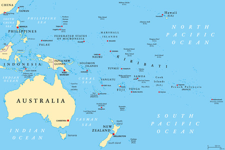
Oceania political map australia and the pacific including new zealand geographic region southeast of the asia pacific region including australasia melanesia micronesia and
Oceania political map australia and the pacific including new zealand geographic region southeast of the asia pacific region including australasia melanesia micronesia and123RF Premium
VectorsSimilar Images
Australia on a world map with vignette and radial blur effect elements of this image are furnished by nasa Stock Photo
Australia on a world map with vignette and radial blur effect elements of this image are furnished by nasa
Similar Images
Australia and oceania map highly detailed vector illustration image contains land contours country and land names city names water object names navigation icons
VectorsSimilar Images
Map of oceania drawn illustrated brush strokes geographic map physics cartography geographical atlas
Map of oceania drawn illustrated brush strokes geographic map physics cartography geographical atlas123RF Premium
Similar Images
Australia on simple blue political globe 3d illustration
Similar Images
Australia and oceania map navigation icons highly detailed vector illustration Stock Photo
Australia and oceania map navigation icons highly detailed vector illustration
VectorsSimilar Images
Low poly map of oceania geometric illustration of the continent oceania polygonal map technology internet network concept vector illustration
Low poly map of oceania geometric illustration of the continent oceania polygonal map technology internet network concept vector illustration123RF Premium
VectorsSimilar Images
South atlantic ocean stralia in close up on the map focus on the name of ocean vignetting effect
Similar Images
Papua new guinea in red on political map with watery oceans 3d illustration
Similar Images
Australia political map of administrative divisions states and teritorries colorful 3d vector map with dropped shadow and country name labels Vector Illustration
Australia political map of administrative divisions states and teritorries colorful 3d vector map with dropped shadow and country name labels123RF Premium
VectorsSimilar Images
Highlighted new zealand on map of oceania with national flag Stock Photo
Highlighted new zealand on map of oceania with national flag
Similar Images
Australia on model of planet earth with country borders and very detailed planet surface and clouds 3d illustration Stock Photo
Australia on model of planet earth with country borders and very detailed planet surface and clouds 3d illustration
Similar Images
Australia on blue political globe 3d illustration isolated on white background
Similar Images
Australia on a world map globe on a gray wall Stock Photo
Australia on a world map globe on a gray wall123RF Premium
Similar Images
Papua new guinea on political globe with embedded flags 3d illustration isolated on white background Stock Photo
Papua new guinea on political globe with embedded flags 3d illustration isolated on white background
Similar Images
Vanuatu in red on detailed model of planet earth 3d illustration isolated on white background
Similar Images
Blank political map of australia 3d earth globe with turquoise blue map vector illustration Vector Illustration
Blank political map of australia 3d earth globe with turquoise blue map vector illustration123RF Premium
VectorsSimilar Images
Old world map Stock Photo
Old world map
Similar Images
Australia and oceania region map of countries in south pacific ocean vector illustration
Australia and oceania region map of countries in south pacific ocean vector illustration123RF Premium
VectorsSimilar Images
Australia and oceania map and navigation icons illustration
VectorsSimilar Images
Australia on the map globe earth globe on ukrainian language close up with a red and green lights Stock Photo
Australia on the map globe earth globe on ukrainian language close up with a red and green lights123RF Premium
Similar Images
Sun shining over a high detailed view of planet earth focused on australia 3d illustration
Sun shining over a high detailed view of planet earth focused on australia 3d illustration123RF Premium
Similar Images
Papua new guinea on planet planet earth with country borders extremely detailed planet surface and clouds 3d illustration Stock Photo
Papua new guinea on planet planet earth with country borders extremely detailed planet surface and clouds 3d illustration
Similar Images
Australia and oceania map vintage detailed vector illustration Stock Photo
Australia and oceania map vintage detailed vector illustration
VectorsSimilar Images
New caledonia on dark globe with yellow world map country highlighted with blue color satellite world projection centered to new caledonia appealing vector illustration
New caledonia on dark globe with yellow world map country highlighted with blue color satellite world projection centered to new caledonia appealing vector illustration123RF Premium
VectorsSimilar Images
Dark globe centered to australia country highlighted with red color on world map satellite world projection captivating vector illustration
Dark globe centered to australia country highlighted with red color on world map satellite world projection captivating vector illustration123RF Premium
VectorsSimilar Images
Australia on a world map globe on a gray wall
Australia on a world map globe on a gray wall123RF Premium
Similar Images
Vertical image of a globe ball on the top of the world map Stock Photo
Vertical image of a globe ball on the top of the world map
Similar Images
Map of australia and nearby countries in historic design
Similar Images
Australia continent map earth globe world map in circle globes web icon vector illustration Stock Photo
Australia continent map earth globe world map in circle globes web icon vector illustration123RF Premium
VectorsSimilar Images
New zealand on planet planet earth with country borders extremely detailed planet surface and clouds 3d illustration Stock Photo
New zealand on planet planet earth with country borders extremely detailed planet surface and clouds 3d illustration
Similar Images
Oceania political map region centered on central pacific ocean islands with melanesia micronesia and polynesia including australasia and malay archipelago illustration english labeling vector Stock Photo
Oceania political map region centered on central pacific ocean islands with melanesia micronesia and polynesia including australasia and malay archipelago illustration english labeling vector
VectorsSimilar Images
Oceania map actual low poly style continent map superb vector illustration
VectorsSimilar Images
Infographics continent australia and oceania blue and gray
VectorsSimilar Images
Vanuatu globe with the shape of the country against zoomed map with its outline isolated on the blue background topographic relief map Stock Photo
Vanuatu globe with the shape of the country against zoomed map with its outline isolated on the blue background topographic relief map123RF Premium
Similar Images
New zealand neighborhood distant perspective with outline of the country shapes only land ocean mask Stock Photo
New zealand neighborhood distant perspective with outline of the country shapes only land ocean mask123RF Premium
Similar Images
Australia and oceania flora and fauna map flat elements animals birds and sea life big set build your geography infographics collection vector illustration
VectorsSimilar Images
Australia from space on earth with country borders very fine detail of the plastic planet surface and blue oceans 3d illustration
Similar Images
Canada in close up on the map focus on the name of country vignetting effect
Similar Images
Illustration of papua new guinea as seen from earth’s orbit during sunset 3d illustration
Similar Images
Australia on planet earth with country borders and highly detailed planet surface and clouds 3d illustration
Similar Images
East asia and oceania map vintage detailed vector illustration
VectorsSimilar Images
Papua new guinea with embedded flag on globe 3d illustration Stock Photo
Papua new guinea with embedded flag on globe 3d illustration
Similar Images
Map of papua new guinea as seen from space on planet earth with clouds and atmosphere 3d illustration Stock Photo
Map of papua new guinea as seen from space on planet earth with clouds and atmosphere 3d illustration
Similar Images
Satellite view of australia on earth with city lights extremely detailed plastic planet surface with real mountains 3d illustration
Similar Images
Map of oceania low poly illustration of the continent purple geometric design polygonal vector illustration
Map of oceania low poly illustration of the continent purple geometric design polygonal vector illustration123RF Premium
VectorsSimilar Images
Australia from space 3d rendering Stock Photo
Australia from space 3d rendering
Similar Images
Australia globe with the shape of the country against zoomed map with its outline shapes only land ocean mask
Australia globe with the shape of the country against zoomed map with its outline shapes only land ocean mask123RF Premium
Similar Images
Country of papua new guinea in red on planet earth in the evening 3d illustration Stock Photo
Country of papua new guinea in red on planet earth in the evening 3d illustration
Similar Images